| Browse this collection | This entry describes an individual archive record or file. Click here to browse the full catalogue for this collection |
| Archive Reference / Library Class No. | D2360/3/52a |
| Title | Cromford tithe map, with enlargement of the village |
| Date | 1841 |
| Description | Surveyor: Joseph Gratton
Scale: 6 inches to 30 chains
Approximate centre of map: 429602,356385 |
| Extent | 1 roll |
| Level | File |
| Repository | Derbyshire Record Office |
| Archive Creator | Diocese of Lichfield, later Southwell, later Diocese of Derby |
| Format | Map/Plan |
| Physical Description | Size: 72 x 160 cm |
| Copies | A digital copy of this item can be viewed on the public computers at the record office. For a microfilm copy of the item, see M/710.
A copy is also available to view via the Derbyshire Heritage Mapping Portal (link below), where it can be overlaid on a modern Ordnance Survey item. |
| Related Material | See D2360/3/52b for the accompanying tithe award, for which a digital copy and transcript is available.
See D3105/A/PI/17/1 and D3105/A/PI/17/2 for the parish copy of the tithe map and award.
See D2360/3/39a, D2360/3/39b and D3105/A/PI/17/3-6 for the altered awards of 1890-1933.
See also D4996/6/7 for a tracing of the map with field names added. |
| Term | Tithe records |
| Tithe maps |
| Image | 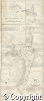
|
| Acknowledgements | Additional catalogue description provided by Derwent Valley Mills World Heritage Site Great Place Scheme project volunteers 2018. |
| Useful Links | https://www.derbyshire.gov.uk/leisure/record-office/records/historic-maps/historic-maps.aspx |